
The Georgia Botanical Society
Dedicated
to the study and preservation of Georgia's wild, native,
rare and endangered wildflowers and plant life
You've reached an old page of our web site. Please visit www.gabotsoc.org for our current site.
Articles-Places: Tugaloo Mosaic
by
John Garst and James Sullivan
Tipularia, Vol. 8, August 1993
click here for printer-friendly version
 |
In northeast Georgia and adjacent South Carolina, there is a remarkable area containing a dazzling diversity of plant life, including many rare, endangered, scarce, threatened, peripheral, and disjunct species. It is a dense mosaic of diverse habitats with soils derived from folded and broken layers of a variety of metamorphic and igneous rocks. We propose that it be called the Tugaloo Mosaic, recognizing that its heart lies in the drainage basin of the Tugaloo River. Although many specific localities within the Tugaloo Mosaic have been recognized for their unusual botany, the region has not been considered previously as an integral unit. We see it as a unique network of communities. It is a precious reservoir of biological diversity that should be protected. |
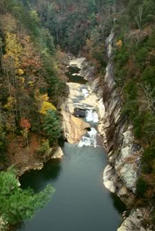
Tallulah Gorge |
Definition and Location The Tugaloo Mosaic is the intersection of the Gainesville Ridges physiographic district with the Savannah River drainage basin. The Gainesville Ridges, a narrow series of ridges and valleys parallel to the Brevard Fault on both sides (Wharton, 1977; Hodler, 1986), crosses Georgia from southwest to northeast, through Atlanta and Gainesville. Most of the Gainesville Ridges drains into the Chattahoochee River, which flows southwest to the Gulf of Mexico, but in Habersham County the Gainesville Ridges is crossed by a divide, east of which the drainage is into the Savannah River and the Atlantic Ocean. The inset map shows the location and extent of the Tugaloo Mosaic in Georgia. The larger map shows some of its major features. From Tallulah Gorge south, the boundaries of the Tugaloo Mosaic in Georgia are nearly coincident with those of the Chattahoochee National Forest. The southeastern boundary is also nearly coincident with Georgia Highway 184. |
|
LEGEND. Inset: Stippled area -Tugaloo Mosaic, dashed lines - major river basin divides, light solid lines - county boundaries, heavy solid lines - boundaries of the Gainesville Ridges. Sites in the Tugaloo Mosaic: TaR - Tallulah River, CR - Chattooga River, TaG - Tallulah Gorge, TgL - Tugaloo Lake, GFC - "Glade Fern Creek", YL - Yonah Lake, PC - Panther Creek, TgR - Tugaloo River, BM - Black Mountain, DC - Davidson Creek, LM - Lee Mountain, CC - Cedar Creek, RQM - Rock Quarry Mountain, CM - Currahee Mountain, NTC - Nancy Town Creek, BLC - Big Leatherwood Creek, LR - Lake Russell, SM - Soapstone Mountain, LLC - Little Leatherwood Creek. |
|
Geology
The density of habitats and diversity of plant life in the Tugaloo Mosaic is a consequence of its geologic, climatologic, hydrologic, and biologic history. The Appalachian region has a complex geologic history (Wicander, 1989). About 500 million years ago, mountain building began, and it continued in episodes that span about 300 million years. As the continental plates of North America and Africa moved back and forth, parts of the region were sometimes submerged under the sea and sometimes uplifted, and the ocean floor and islands were shoved up onto a stable interior, the craton. Strata folded, buckled, and melted, producing volcanic activity and metamorphism. Weathering occurred constantly, and hydrologic and biologic as well as climatologic forces molded the landscape. The Brevard Fault and Gainesville Ridges are consequences of these activities.
Most geologists identify the Brevard Fault as the interface between the Blue Ridge and the Piedmont (Hack, 1982). Thus, the Gainesville Ridges, and therefore the Tugaloo Mosaic, is part Blue Ridge, part Brevard Fault, and part Piedmont.
 |
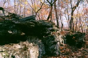 |
Above: Amphibolite outcrops
As a direct consequence of its interfacial location, the landscapes of the Tugaloo Mosaic have been molded by special hydrologic forces. There is strong evidence that the Chattooga River was, long ago, the upper part of the Chattahoochee River (Johnson, 1907). By erosion, the headwaters of streams move upstream. In this way the Tugaloo River, long ago rising somewhere in the Piedmont, ate its way into the edge of the Blue Ridge, intersected the Chattooga-Chattahoochee River, and captured its upper branches (now the Chattooga and Tallulah River), diverting them into the Savannah River and cutting off the Chattahoochee to form a separate river.
Tallulah Gorge was cut by the upstream progression of Tallulah Falls, which cut into dense, erosion-resistant quartzite, a process that would be continuing today if the river were still flowing over the falls (it was dammed at the head of the falls in the early twentieth century). On the Chattooga River, the rocks are a mica schist that is less resistant to erosion. Erosion and weathering have already levelled the course of the river, eliminating the falls that are believed to have been present earlier. On smaller scales, downcutting occurred at many other places in the Tugaloo Mosaic, producing waterfalls and deep ravines, gorges, and canyons, such as those on Davidson, Panther, and Cedar Creeks.
Sedimentation, volcanic activity, and metamorphism produced strata of a variety of rocks. Folding, buckling, and weathering exposed these strata at the surface and produced a mosaic of soils. Downcutting by streams flowing from the Blue RIdge to the Piedmont also exposed different strata in the resulting ravines, gorges, and canyons. These features play a very imprtant role in supporting plant diversity in the Tugaloo Mosaic.
For example, dolomitic limestone crops out as marble on Davidson and Panther Creeks and at other places along the Brevard Fault, producing circumneutral calcium-rich soils for which certain plants (calciphiles) have strong preferences. Otherwise, limestone is not found in this region. In much of northeast Georgia, the soils contain less calcium and are more acidic.
Other rocks of the Tugaloo Mosaic are mafic (rich in magnesium and iron, as well as calcium) and may be preferred by some plants. Ultramafic rocks contain even more magnesium and iron but are markedly deficient in calcium, and the soils derived from these rocks support a distinctive vegetation (Dann, 1988; Roberts, 1992). Ultramafic rocks are occasionally exposed in the Tugaloo Mosaic, but their mapping is very incomplete and the accompanying plant communities have not been detailed.
Because different plants are adapted to different soils and conditions, the Tugaloo Mosaic provides possible homes for a wide variety of species. However, they would not be there had they never arrived. Many of them got to the Tugaloo Mosaic when shifting south or north in response to climatic changes.
 |
The ice ages provided the cooling temperatures that drove northern species south as glaciers dipped into the northern states (Pielou, 1991). Southern species tolerated the cooler temperatures, shifted south or survived in refugia (hospitable niches such as canyons and river bottoms with southern exposures). When temperatures rose again, southern species emerged from their refugia and repopulated the area. Northern species, unable to tolerate the increasing temperatures as well as their competitors, died out or shifted north, except where they found refugia (high altitudes, north-facing mountain slopes and river bluffs, gorges, canyons, and ravines with northern exposures).
|
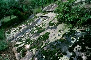
Rock Outcrop on Currahee Mountain |
The Tugaloo Mosaic is rich in sites offering refuge to a variety of northern and southern plants. |
Botanical Diversity
The ravines, canyons and gorges of the Tugaloo Mosaic provide much of its botanical diversity. In a brief survey, we begin in the Tugaloo River basin, with Tallulah Gorge, and move south and west.
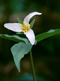 |
Tallulah Gorge is the northernmost site for Edna's trillium (Trillium persistens, persistent trillium), a Tugaloo Mosaic endemic and federal endangered species. [See Garst's Byliner, inside cover.] It is also home for the monkey-face orchid (Platanthera integrilabia), an object of considerable recent interest among Botanical Society members. In Tallulah Gorge, poison sumac (Toxicodendron vernix, which is scarce in the Piedmont and Blue Ridge but more abundant in the Coastal Plain of Georgia and in northern states) and bamboo smilax (Smilax laurifolia) can be regarded as southern elements. The ravines of several creeks that flow into Tugaloo and Yonah Lakes harbor Edna's trillium. Another, "Glade Fern Creek," an unnamed tributary of Yonah Lake, contains a large population of glade fern (Homalosorus pycnocarpos), which is scarce in Georgia, along with many other northern species.
|
Trillium persistens |
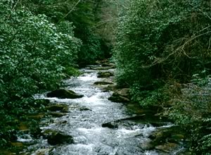 |
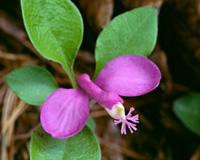
Panther Creek is most amazing. The staggering diversity of plants along this creek between U.S. 441 and its mouth is almost unbelievable. The rare tree yellowwood (Cladrastis kentukea) grows here. So do six species of trillium, two of which are rare: T. persistens (endangered), T. discolor (rare and diminishing), T. rugelii (in unusual forms in marble areas), T. catesbaei, T. cuneatum and T. vaseyi. Of the nine species of native stemmed violets listed by Wofford (1989), eight grow on Panther Creek, including the American dog violet (V. conspersa), which is rare in Georgia; only the long-spurred violet (Viola rostrata) is absent. There is also green violet (Hybanthus concolor). In the spring, there are dazzling displays of gay wings (Polygala paucifolia), another northern species that is infrequent in Georgia and that reaches its southern limits along the Brevard Fault. |
Panther Creek |
Similarly, bishop's cap (Mitella diphylla), Canada waterleaf (Hydrophyllum canadense) and the large purple phacelia (Phacelia bipinnatifida), which are all at home in the Great Smokies, grow here in disjunct populations. Panther Creek has many orchids, including pink and yellow lady's slippers (Cypripedium acaule and C. calceolus), spring coral root (Corallorhiza wisteriana), large whorled pogonia (Isotria verticillata) and three birds orchid (Triphora trianthophora). It has ginseng (Panax quinquefolius) and bay starvine (Schisandra glabra). And it has numerous uncommon ferns, including glade fern; Goldie's fern (Dryopteris goldiana); walking fern (Asplenium rhizophyllum), a calciphile; Peters' filmy fern (Trichomanes petersii), a dwarf fern that grows here in large sheets at several locations; Alabama slip fern (Cheilanthes alabamensis) and blackstem spleenwort (Asplenium resiliens), which is otherwise found in Georgia in the limestone areas of the northwest and the Coastal Plain. |
Polygala paucifolia |
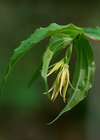 |
Davidson Creek, a tributary of Panther Creek, also flows over strata of various rocks, including marble. It harbors Clinton's lily (Clintonia umbellulata), yellow mandarin (Disporum lanuginosum), fly poison (Amianthum muscaetoxicum), American dog violet, green violet and bishop's cap, as well as pink and yellow lady's slipppers. Rothwell (Walker) Creek features Trillium discolor and several orchids, including lily-leaved twayblade (Liparis lilifolia), puttyroot (Aplectrum hymenale) and yellow lady's slipper. In Cedar Creek Canyon, southern maidenhair fern (Adiantum capillus-veneris) occurs far north of its usual range. This is also another haven for Peters' filmy fern, walking fern and lily-leaved twayblade. In the basin of the Middle Fork Broad River, west of Toccoa, is a site for the unusual shrub, Nestronia umbellula. Also, in the basin of the Middle Fork Broad River, Little Leatherwood Creek features the scarce shrub leatherwood (Dirca palustris), as well as grass-of-parnassus (Parnassia asarifolia), lily-leaved twayblade, and several other orchids. Nancy Town Creek and Lake Russell have the pink lady's slipper and other treaures. |
Disporum lanuginosum |
In many places in the Tugaloo Mosaic, including most of those mentioned above, the beautiful purple stoneroot (Collinsonia verticillata) is abundant. The rare lobed barren strawberry (Waldensteinia lobata) is common in the Tugaloo River basin.
The diversity of the Tugaloo Mosaic is not limited to the moist areas of the ravines, canyons, and gorges. Indeed, Table Mountain pine (Pinus pungens), an Appalachian Mountain endemic, reaches its southern limit here on the dry ridgetops. On the rim of Tallulah Gorge, also at its southern limit, is Carolina hemlock (Tsuga caroliniana). Also on the rim is the American climbing fern (Lygodium palmatum). From the rim woods there are historic records of the elusive sweet pinesap (Monotropis odorata) and turkey-beard (Xerophyllum asphodeloides). They should be sought.
The smooth purple coneflower (Echinacea laevigata), which was recently federally listed as endangered, grows in exposed dry spots on the slopes of Lee, Rock Quarry and Currahee Mountains. It may prefer soils over mafic rocks. It is found on Currahee Mountain near curlyheads (Clematis ochroleuca), an ultramafic associate elsewhere.
There are sphagnum bogs containing the monkey-face orchid on the slopes of Lee Mountain and Tallulah Gorge. On Lee Mountain and elsewhere in the Tugaloo Mosaic, there are sizable rock outcrops, some of which bear typical Piedmont granite outcrop vegetation.
Imposing the pattern of wet or dry on the pattern of slope steepness and aspect, and that on the finely divided, chemically diverse soils and bedrock creates a very diverse flora. Many of the plants mentioned above are habitat specialists. For example, a road bank on Currahee Mountain provides a relatively dry spot, on a steep slope, with sparse trees and frequently exposed mafic soils in which grow smooth purple coneflowers. This is a very specific habitat! We can only guess what the habitats of this species were like originally.
Need for Botanical Inventory
The Tugaloo Mosaic in Georgia needs a better botanical inventory. The selection of interesting plants given above is an incomplete record of what is found there. A great deal remains to be explored, especially the Broad River basin (including the Lake Russell Wildlife Management Area) and the area east and north of Tallulah Gorge. Even the names on the map suggest that further rare, unusual and diverse plants will be found. In addition to Big and Little Leatherwood Creeks, there is Soapstone Mountain. Although "soapstone" may be used loosely, it usually refers to impure talc. It is a soft ultramafic rock that is frequently associated with serpentine (Dann, 1988). If it occurs on Soapstone Mountain, then a distinctive flora is to be expected there.
Need for Protection and Preservation
The Tugaloo Mosaic should be recognized by federal, state and local governments as an integral area of great botanical significance and value. Agencies that manage the land should protect and preserve the plant communities in the Tugaloo Mosaic. They should promote the restoration of native vegetation as much as possible, allowing maturity to old-growth conditions or fire-maintained communities, as appropriate.
The presence of rare plants in dry habitats and bogs in unusual places exposes a critical weakness of any approach to management that focuses only on the "rich" moist areas of the ravines, canyons, and gorges. Such a focus would withhold protection from dry or unusual areas that are responsible for part of the biological diversity of the Tugaloo Mosaic. In addition, the close proximities of the densely-packed diverse habitats makes it likely that they are ecologically interdependent, so that a failure to protect some areas could have adverse effects on those nearby that are chosen for protection. The only effective approach is to protect the entire area.
The U.S. Forest Service and Georgia Power Company manage about half of the Tugaloo Mosaic in Georgia. Two large blocks of Chattahoochee National Forest land anchor the two ends of the Tugaloo Mosaic. The northeastern block is the Tugaloo River basin, which includes Tallulah Gorge and Black and Lee Mountains. The southwestern block is the Broad River basin, which includes Currahee Mountain and the headwaters of the North and Middle Forks Broad River. The Georgia Power Company owns Tallulah Gorge and significant parts of the ravines of the tributary creeks of the Tallulah, Chattooga, and Tugaloo Rivers. The State of Georgia has recently entered into an agreement with the Georgia Power Company for the joint management of Tallulah Gorge.
Much of the public land in the Tugaloo Mosaic has been managed for timber production and other purposes that are often detrimental to the unique habitats and plant diversity. For example, Table Mountain pine has been largely extirpated here by fire suppression, stand conversion to loblolly pine, and past timber and agricultural practices. The intensity of timber management in the Tugaloo Mosaic in recent years approaches the limits of sustainability. Seventy to ninety percent of timber harvests in the Chattooga Ranger District occur on this thirty percent of the district. The quality of aquatic environments is severely impacted by a system of poorly designed and maintained roads.
The density of the road system precludes any chance for wilderness areas and very little acreage is classified as unsuitable for timber production. Under these circumstances, there is little potential for old growth conditions to develop in the National Forest, or on the rapidly developing private lands of the Tugaloo Mosaic.
The National Forest lands in the Tugaloo Mosaic receive intense recreational use from both local residents and tourists. These lands are interspersed with a rapidly developing residential and agricultural landscape that is maintained in nearly perpetual early successional environments.
All along the Gainesville Ridges (and on nearby lands) southwest of the Tugaloo Mosaic, in the Chattahoochee River basin, there are botanical sites with unusual and diverse species. The Tugaloo Mosaic contains exceptional diversity, but the remainder of the Gainesville Ridges is also valuable. However, the only large tracts of public land in the entire Gainesville Ridges in Georgia are in the Tugaloo Mosaic. There is no other opportunity to restore natural forest and aquatic environments in the Gainesville Ridges in Georgia on such a large scale.
A Management Plan
The first priorities in a management of the Tugaloo Mosaic are protection of the unique botanical and habitat resources and the restoration of forest and aquatic environments. It would be best to terminate all timber harvesting in the Tugaloo Mosaic, pending further study of the area. At the very least, several large tracts should be set aside immediately for protection of unique habitats - such as the Tugaloo River basin from Tallulah Gorge south, including the tributaries of Tugaloo and Yonah Lakes; Panther, Davidson, Rothwell and Cedar Creeks; Black and Lee Mountains; and all of the associated terrain. Another tract is Currahee Mountain and its associated ridges and slopes. Within these areas, forest environments with a natural composition of species should be protected to achieve old growth structure and dynamics on their own. A timber program would be involved to restore those areas converted by past timber management and agriculture to more natural conditions.
There should be competent inventories of all unique and sensitive botanical sites on National Forest lands in the Tugaloo Mosaic. Protection from all impacts, originating on or off the site, should be ensured.
If a timber program continues on the remaining suitable land, uneven-age methods that maintain some structural identity with old growth conditions should be used. The objective should be to maintain late successional and old growth characteristics.
The headwater areas of the North Fork and Middle Fork Broad Rivers should be managed for watershed restoration. Headwaters of other rivers originating in the upper Piedmont are already heavily developed, and the opportunity to restore these public watersheds to natural quality with a complement of native aquatic species must not be overlooked.
The Georgia Power Company and the State of Georgia should see that Tallulah Gorge is managed for the protection of its biodiversity. Any construction, even on the rim above the gorge itself, is a potential threat. For example, the recent construction of U.S. Highway 441 at the rim of the gorge resulted in mudslides into the gorge that destroyed several dozen individuals of Trillium persistens, including one "permanent" study plot.
It is hoped that the Georgia Power Company will also manage their properties on Tugaloo and Yonah Lakes with the protection of biodiversity as a key element. The company has expressed and demonstrated its commitment to the protection of Trillium persistens there. There is no present development on Tugaloo Lake, and it is hoped that there will be none in the future. About 50 lots have been leased on Yonah Lake, which receives moderate to heavy recreational use. On the Georgia side of the lake, the area surrounding Moccasin Creek is especially sensitive for its populations of Trillium persistens. A little further south, the ravine of Glade Fern Lake is a rich, sensitive area.
The Tugaloo Mosaic is unique and valuable, and much of it is ours (public land). We must work to protect it.
©Article
by John Garst and James Sullivan, Tipularia, Vol. 8, August 1993
©Photographs
by Hugh and Carol Nourse
Anita Reaves, Membership Chair
770-827-5186
All contents
of this website(except where otherwise noted) ©2002-2007 Georgia Botanical
Society.
All rights reserved.
The Georgia Botanical Society is a private non-profit organization under IRS
501(c)3, Founded in 1926.
Questions, comments or problems with this website, please contact: webmaster@gabotsoc.org
Home | Newsletter | Field Trips | Tipularia | Links | Articles | Contact Us | Join!