
The Georgia Botanical Society
Dedicated
to the study and preservation of Georgia's wild, native,
rare and endangered wildflowers and plant life
Articles-Places:
Tallulah Gorge
click
here for printer-friendly version
You've reached an old page of our web site. Please visit www.gabotsoc.org for our current site.
 Tallulah
Gorge is a dramatic, deep gorge strewn with spectacular waterfalls. It is
also a botanical treasure house: the steep, nearly inaccessible cliffs are
a haven for threatened species. Rare, unusual and endangered species found
in the gorge include the persistent trillium (Trillium persistens),
monkeyface orchid (Platanthera integrilabia), hairy mock-orange (Philadelphus
hirsutus), the green salamander (Aneides aeneus); grass-of-parnassus
(Parnassia asarifolia), grass pink orchid (Calopogron pulchellus),
round-leaved sundew (Drosera rotundifolia), Carolina tassel-rue (Trautvetteria
carolinensis), dwarf filmy fern (Trichomanes petersii), and Carolina
hemlock (Tsuga caroliniana). The discussion below ties together the
geology, soils, topography and vegetation of Tallulah Gorge.
Tallulah
Gorge is a dramatic, deep gorge strewn with spectacular waterfalls. It is
also a botanical treasure house: the steep, nearly inaccessible cliffs are
a haven for threatened species. Rare, unusual and endangered species found
in the gorge include the persistent trillium (Trillium persistens),
monkeyface orchid (Platanthera integrilabia), hairy mock-orange (Philadelphus
hirsutus), the green salamander (Aneides aeneus); grass-of-parnassus
(Parnassia asarifolia), grass pink orchid (Calopogron pulchellus),
round-leaved sundew (Drosera rotundifolia), Carolina tassel-rue (Trautvetteria
carolinensis), dwarf filmy fern (Trichomanes petersii), and Carolina
hemlock (Tsuga caroliniana). The discussion below ties together the
geology, soils, topography and vegetation of Tallulah Gorge.
Geology
 Current
theory holds that this spectacular gorge was once sand on the beach of an
island that existed in a pre-Atlantic Ocean (Iapetus) off the shore of Laurentia,
a landmass that included part of ancient North America and Greenland. Over
time, the sand was turned into sandstone through cementing and pressure.
Current
theory holds that this spectacular gorge was once sand on the beach of an
island that existed in a pre-Atlantic Ocean (Iapetus) off the shore of Laurentia,
a landmass that included part of ancient North America and Greenland. Over
time, the sand was turned into sandstone through cementing and pressure.
During the Paleozoic era, (between 500 and 245 million years ago) as Iapetus
closed, the Appalachian Mountains rose and the supercontinent Pangaea formed,
plate tectonics bulldozed the sandstone into what is now southeastern North
America. The sandstone was thrust faulted (moved horizontally) two hundred
miles inland over the billion-year-old North American crust. The mountain
building generated heat and pressure that metamorphosed the sandstone into
quartzite, a very strong, erosion-resistant rock. (The most common quartzite
here contains the primary mineral quartz with the accessory minerals muscovite,
biotite, microcline, plagioclase, and carbonate.) Shale derived from muddy
sediments was thrust along with the sandstone and metamorphosed - recrystallized
by heat and pressure - into schist (with the minerals muscovite and biotite)
which is interlayered with the quartzite.
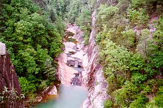
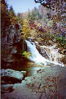
The bottom of Hurricane Falls during a large release of water from the dam. The layers of quartzite tilting on the steep gorge walls testify to the geologic upheavals of the past.
Forming the Gorge
 Millions
of years later in the Pleistocene epoch in this part of Georgia, the Appalachian
Mountains were forest-covered and gentle-sloped remnants of the violently
born Paleozoic range. The Savannah-Tugaloo River was shorter than it is today,
and back-cut from the Atlantic through Coastal Plain rock towards the Chattahoochee
River by constantly eroding the rocks at its headwaters. At that time, the
Chattooga River was part of the Chattahoochee. The Savannah-Tugaloo eventually
intercepted the Chattahoochee-Chattooga, and, being deeper, diverted what
is now the Chattooga away from the Chattahoochee - a process known as "river
piracy". River piracy forms a signature elbow, and gives Georgia its distinctive
northern boundary line. The Tallulah River continued back-cutting and down-cutting.
Upon reaching the resistant quartzite, the river could not meander as it could
through softer materials, and so it sliced down through the quartzite to create
the steep-walled gorge.
Millions
of years later in the Pleistocene epoch in this part of Georgia, the Appalachian
Mountains were forest-covered and gentle-sloped remnants of the violently
born Paleozoic range. The Savannah-Tugaloo River was shorter than it is today,
and back-cut from the Atlantic through Coastal Plain rock towards the Chattahoochee
River by constantly eroding the rocks at its headwaters. At that time, the
Chattooga River was part of the Chattahoochee. The Savannah-Tugaloo eventually
intercepted the Chattahoochee-Chattooga, and, being deeper, diverted what
is now the Chattooga away from the Chattahoochee - a process known as "river
piracy". River piracy forms a signature elbow, and gives Georgia its distinctive
northern boundary line. The Tallulah River continued back-cutting and down-cutting.
Upon reaching the resistant quartzite, the river could not meander as it could
through softer materials, and so it sliced down through the quartzite to create
the steep-walled gorge.
Down-cutting to form a gorge in geologic time. The Tallulah River works inexorably to break away a slab of Oceana Falls.
Soils
Since the ancient beaches that formed the Tallulah quartzite were primarily sterile sands, when the quartzite erodes it forms soils that are generally low-nutrient, acidic, and sandy (typically sandy loams). Biotite, muscovite and microcline minerals in the quartzite and/or schist will add small amounts of potassium and/or magnesium; other plant nutrients are rarer still. Topography greatly affects the soil formation. Concave shapes and gentle or flat slopes allow soil particles and organic matter to collect, creating deeper soils that can hold more water and provide deeper rooting material for plants. Both nutrients and water adhere to the clays and humus (highly decomposed organic matter) that collect, further increasing both the soil's water holding capacity and nutrient levels. In contrast, convex, steep slopes shed water, soil particles and organic material, resulting in thin, sandy, and nutrient-poor soils: on the rim and steep walls of the canyon, the soils are thin to non-existent.
Vegetation Communities
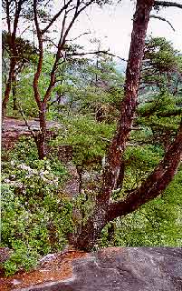
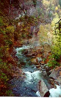
 Tallulah
gorge is an ideal place to observe the effects of topography and aspect (the
compass direction a slope is facing) upon vegetation. Aspect greatly
affects the amount of sunlight a slope receives. Because the sun arcs from
the east through the south to the west, south-facing slopes receive far more
sun than north-facing ones. Southwest-facing slopes get particularly warm
because the sun beams at them in the afternoon, when the day's heat has built
up to its maximum. Northeast slopes stay the coolest. The photo here, just
upstream of Bridal Veil Falls, is facing west. Note how much sunnier the south
facing (right) side of the gorge is. The amount of sun a site receives greatly
affects moisture conditions because high temperatures evaporate moisture from
the soils and force plants to transpire (in a sense to "exhale") moisture.
So north-facing slopes are both cooler and moister.
Tallulah
gorge is an ideal place to observe the effects of topography and aspect (the
compass direction a slope is facing) upon vegetation. Aspect greatly
affects the amount of sunlight a slope receives. Because the sun arcs from
the east through the south to the west, south-facing slopes receive far more
sun than north-facing ones. Southwest-facing slopes get particularly warm
because the sun beams at them in the afternoon, when the day's heat has built
up to its maximum. Northeast slopes stay the coolest. The photo here, just
upstream of Bridal Veil Falls, is facing west. Note how much sunnier the south
facing (right) side of the gorge is. The amount of sun a site receives greatly
affects moisture conditions because high temperatures evaporate moisture from
the soils and force plants to transpire (in a sense to "exhale") moisture.
So north-facing slopes are both cooler and moister.
Topography also greatly affects vegetation in Tallulah gorge because,
like aspect, it regulates sunlight (heat) and moisture. The lower slopes of
the gorge stay shaded for much of the day, and so stay moister. Slope shape
and gradient also direct water flow towards some sites and away from others.
So, lower and concave slopes receive moisture, while upper and convex slopes
shed water.
The Tallulah River flows northwest to southeast, so the cliff walls are generally
north and south facing. As the river twists and turns through the gorge, it
constantly changes aspect, and erosion has carved a myriad of topographic
shapes. Thus the Tallulah has created a wide range of conditions, from xeric
(very dry) to mesic (moist) to hydric (often saturated), and the vegetation
communities reflect the river's work.
Xeric communities
 Xeric
conditions occur on the most exposed, stoniest soils of the rim and steep
upper slopes of the gorge, particularly in south to southwest-facing areas.
The soils are thin, acidic, nutrient-poor and fast draining. South-facing
upper cliff walls and rims possess the "triple whammy" of exposure to the
drying conditions of the sun for most of the day, thin, sterile soils caused
by the topography and quartzite bedrock, and water loss down steep slopes.
Plants in these communities are adapted to both drought and low nutrient conditions.
Pine and oak, sometimes dwarfed, are the dominant canopy taxa. Pines include
Virginia pine (Pinus virginiana), shortleaf pine (P. echinata),
table mountain pine (P. pungens), and pitch pine (P. rigida).
Oaks include blackjack oak (Quercus marilandica), chestnut oak (Q.
prinus), post oak (Q. stellata) and scarlet oak (Q. coccinea).
Eastern red cedar (Juniperus virginana) may also be present. The shrub
layer includes mountain laurel (Kalmia latifolia) sparkleberry (Vaccinium
arboreum) and blueberry (Vaccinium corymbosum).
Xeric
conditions occur on the most exposed, stoniest soils of the rim and steep
upper slopes of the gorge, particularly in south to southwest-facing areas.
The soils are thin, acidic, nutrient-poor and fast draining. South-facing
upper cliff walls and rims possess the "triple whammy" of exposure to the
drying conditions of the sun for most of the day, thin, sterile soils caused
by the topography and quartzite bedrock, and water loss down steep slopes.
Plants in these communities are adapted to both drought and low nutrient conditions.
Pine and oak, sometimes dwarfed, are the dominant canopy taxa. Pines include
Virginia pine (Pinus virginiana), shortleaf pine (P. echinata),
table mountain pine (P. pungens), and pitch pine (P. rigida).
Oaks include blackjack oak (Quercus marilandica), chestnut oak (Q.
prinus), post oak (Q. stellata) and scarlet oak (Q. coccinea).
Eastern red cedar (Juniperus virginana) may also be present. The shrub
layer includes mountain laurel (Kalmia latifolia) sparkleberry (Vaccinium
arboreum) and blueberry (Vaccinium corymbosum).
Sub-xeric communities
 Sub-xeric
conditions occur on less steep upper or middle slopes - particularly south
to southwest facing slopes. Topography enables just thin, well-drained, nutrient-poor
soils to develop; little water collects, and sunlight evaporates much moisture
away. Two communities tend to develop. Oak-pine communities include chestnut
oak (often dominant), blackjack oak, post oak, scarlet oak, Virginia pine,
shortleaf pine, table mountain pine, eastern white pine (Pinus strobus),
sourwood (Oxydendrum arboreum), scarlet oak, blackjack oak, post oak,
chestnut oak, American holly (Ilex opaca) in protected areas, and,
very rarely, Carolina hemlock (Tsuga carolinia). Shrubs include mountain
laurel, flame azalea (Rhododendron calendulaceum), blueberry, sparkleberry
and catawba rhododendron (Rhododendron catawbiense). Virginia-white
pine communities occur on stonier slopes, perhaps because the light seeds
are better able to root than the larger acorns in the stony areas; the wind
easily transports them to less accessible sites; and pine seedlings are superior
competitors in dry soils. Virginia pine dominates more upslope, and white
pine in the cooler, moister downslope areas.
Sub-xeric
conditions occur on less steep upper or middle slopes - particularly south
to southwest facing slopes. Topography enables just thin, well-drained, nutrient-poor
soils to develop; little water collects, and sunlight evaporates much moisture
away. Two communities tend to develop. Oak-pine communities include chestnut
oak (often dominant), blackjack oak, post oak, scarlet oak, Virginia pine,
shortleaf pine, table mountain pine, eastern white pine (Pinus strobus),
sourwood (Oxydendrum arboreum), scarlet oak, blackjack oak, post oak,
chestnut oak, American holly (Ilex opaca) in protected areas, and,
very rarely, Carolina hemlock (Tsuga carolinia). Shrubs include mountain
laurel, flame azalea (Rhododendron calendulaceum), blueberry, sparkleberry
and catawba rhododendron (Rhododendron catawbiense). Virginia-white
pine communities occur on stonier slopes, perhaps because the light seeds
are better able to root than the larger acorns in the stony areas; the wind
easily transports them to less accessible sites; and pine seedlings are superior
competitors in dry soils. Virginia pine dominates more upslope, and white
pine in the cooler, moister downslope areas.
Sub-mesic communities
 Topography
and aspect enable north to northeast facing slopes, protected south to southwest
facing slopes, and gentle slopes behind the rim to retain more moisture and
grow deeper, richer soils than the sub-xeric and xeric areas.Thus, plants
without the thick, waxy needles and leaves needed in the driest areas can
be found here. Nutrient levels remain low due to the quartzite-schist bedrock.
Dominant species include chestnut oak, white oak (Quercus alba), black oak
(Q. velutina), scarlet oak, pignut hickory (Carya glabra), red maple (Acer
rubrum), sweetgum (Liquidambar styraciflua), sourwood, dogwood (Cornus florida),
America holly, Canadian hemlock (Tsuga canadensis) on lower sites, and eastern
white pine. Shrubs include blueberry, mountain laurel, pinxter flower (Rhododendron
nudiflorum), maple-leaved viburnum (Viburnum acerifolium), and dog-hobble
(Leucothoe fontanesiana).
Topography
and aspect enable north to northeast facing slopes, protected south to southwest
facing slopes, and gentle slopes behind the rim to retain more moisture and
grow deeper, richer soils than the sub-xeric and xeric areas.Thus, plants
without the thick, waxy needles and leaves needed in the driest areas can
be found here. Nutrient levels remain low due to the quartzite-schist bedrock.
Dominant species include chestnut oak, white oak (Quercus alba), black oak
(Q. velutina), scarlet oak, pignut hickory (Carya glabra), red maple (Acer
rubrum), sweetgum (Liquidambar styraciflua), sourwood, dogwood (Cornus florida),
America holly, Canadian hemlock (Tsuga canadensis) on lower sites, and eastern
white pine. Shrubs include blueberry, mountain laurel, pinxter flower (Rhododendron
nudiflorum), maple-leaved viburnum (Viburnum acerifolium), and dog-hobble
(Leucothoe fontanesiana).
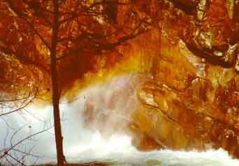
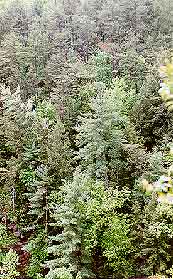
Looking from the bottom of Hurricane Falls up to a sub-mesic community during the release of water from the dam.
Mesic communities
 Lower
slopes near the river that are protected by steep cliffs from sun and wind
exposure, and north to northeast facing coves and ravines are moist environments.
Nutrient-retaining clays and humus can collect more to form somewhat deeper,
richer soils. Plants best able to compete under low sun conditions and higher
moisture and nutrient levels are found in these environments. Common trees
include tulip poplar (Liriodendron tulipifera), white oak, beech (Fagus
grandifolia), Carolina hemlock, dogwood, sweetgum, red maple, sourwood,
northern red oak (Quercus rubrus), and Fraser magnolia (Magnolia
fraseri). Shrubs include paw paw (Asimina triloba), witch hazel
(Hammamelis virginiana) rosebay rhododendron (Rhododendron maximum),
wild hydrangea (Hydrangea arborescens) and sweet shrub (Calycanthus
floridus).
Lower
slopes near the river that are protected by steep cliffs from sun and wind
exposure, and north to northeast facing coves and ravines are moist environments.
Nutrient-retaining clays and humus can collect more to form somewhat deeper,
richer soils. Plants best able to compete under low sun conditions and higher
moisture and nutrient levels are found in these environments. Common trees
include tulip poplar (Liriodendron tulipifera), white oak, beech (Fagus
grandifolia), Carolina hemlock, dogwood, sweetgum, red maple, sourwood,
northern red oak (Quercus rubrus), and Fraser magnolia (Magnolia
fraseri). Shrubs include paw paw (Asimina triloba), witch hazel
(Hammamelis virginiana) rosebay rhododendron (Rhododendron maximum),
wild hydrangea (Hydrangea arborescens) and sweet shrub (Calycanthus
floridus).
Riparian communities
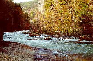
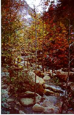 A
walk along the river channel, clambering over large boulder and waterfalls,
is an exciting and beautiful one, particularly in the fall, when the sourwood
leaves gleam scarlet. When Tallulah Gorge was dammed in the early 1900's,
water no longer flowed regularly through some boulder runs along the channel,
and species adapted to hydric conditions were able to expand their range along
the channel into the bars. (The photograph here was taken during a release;
note the trees and shrubs are inundated.) Water releases from the dam are
more frequent now, and may cause the ranges of these species to contract once
again. Species occurring on and near the boulder bars include sweet gum, hazel
alder (Alnus serrulata), Virginia sweetspire (Itea virginica),
sourwood, red maple, tulip poplar, Vitis rotundifolia, sycamore, (Platanus
occidentalis), Virginia pine, yellow root (Xanthorhiza simplicissima),
cross vine (Bignonia capreolata), swamp dogwood (Cornus ammomum),
possumhaw (Viburnum nudum), sparkleberry, royal fern (Osmunda regalis),
and climbing hydrangea (Decumaria barbara). Canadian hemlock and witch
hazel (Hamamelis virginiana) often hug the edges of the bars.
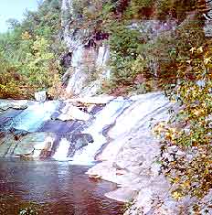
A
walk along the river channel, clambering over large boulder and waterfalls,
is an exciting and beautiful one, particularly in the fall, when the sourwood
leaves gleam scarlet. When Tallulah Gorge was dammed in the early 1900's,
water no longer flowed regularly through some boulder runs along the channel,
and species adapted to hydric conditions were able to expand their range along
the channel into the bars. (The photograph here was taken during a release;
note the trees and shrubs are inundated.) Water releases from the dam are
more frequent now, and may cause the ranges of these species to contract once
again. Species occurring on and near the boulder bars include sweet gum, hazel
alder (Alnus serrulata), Virginia sweetspire (Itea virginica),
sourwood, red maple, tulip poplar, Vitis rotundifolia, sycamore, (Platanus
occidentalis), Virginia pine, yellow root (Xanthorhiza simplicissima),
cross vine (Bignonia capreolata), swamp dogwood (Cornus ammomum),
possumhaw (Viburnum nudum), sparkleberry, royal fern (Osmunda regalis),
and climbing hydrangea (Decumaria barbara). Canadian hemlock and witch
hazel (Hamamelis virginiana) often hug the edges of the bars.
©Text and photographs/images by Leslie Edwards
Anita Reaves, Membership Chair
770-827-5186
All contents
of this website(except where otherwise noted) ©2002-2007 Georgia Botanical
Society.
All rights reserved.
The Georgia Botanical Society is a private non-profit organization under IRS
501(c)3, Founded in 1926.
Questions, comments or problems with this website, please contact: webmaster@gabotsoc.org
Home | Newsletter | Field Trips | Tipularia | Links | Articles | Contact Us | Join!